The Cariboo’s snowpack levels are at normal levels for this time of year according to the BC River Forecast Centre.
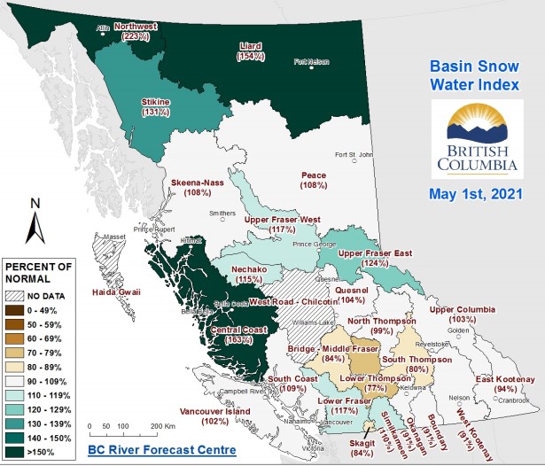
BC River Forecast Hydrologist Jonathan Boyd says the Quesnel watershed is coming at 104% of normal, which is essentially normal. He says that’s a drop from April 1st, which was at 109%.
The West Road Chilcotin did not have data, Boyd says that’s because of limited stations in the area. “There were measurements done, and they all came in at zero, they all have historically come in at zero” Boyd explains, “It’s kind of like ‘zero divided by zero’ doesn’t create any measurement”. Boyd says this just means there is no snow at the areas where the stations are, but there could be snow at higher elevations.
Boyd says much of the flooding that occurred in the Cariboo during April were not caused by a high snowpack. “The big push that happened in Mid-April where we had the extremely hot temperatures, it was province-wide,” Boyd explains, “Unfortunately for the Cariboo region, it was a region that was susceptible to that first initial heatwave with the lower and mid-elevation snow.”
Boyd says the snow in the lower and mid-elevations is mostly gone, but there’s still snow in the higher elevations. “The biggest risk right now would be if we did end up with another significant hot spell, which isn’t in the forecast,” Boyd says.
Overview:
Quesnel Basin – 104%
Bridge – Middle Fraser – 84%
North Thompson – 99%
Upper Fraser East – 124%
Upper Fraser West – 117%
West Road – Chilcotin – No Data
Something going on in the Cariboo you think people should know about?
Send us a news tip by emailing [email protected].


