


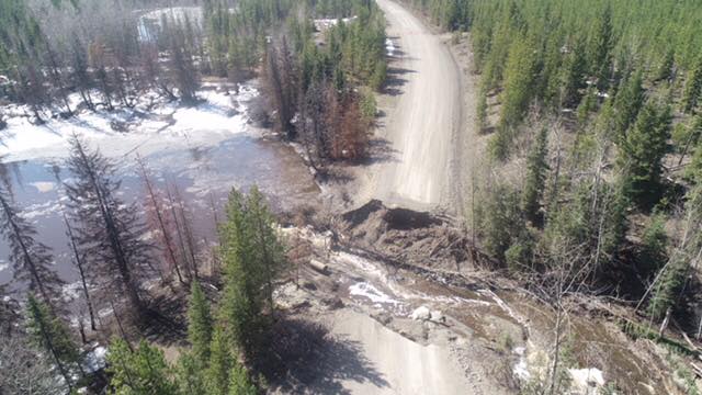
A state of local emergency for Electoral Area I has been declared by the Cariboo Regional District as an evacuation order for the upper Nazko area due to flooding has expanded to 74 properties.
“Members of the RCMP will be going door to door with the evacuation order on Monday
morning” said EOC public information officer Emily Epp.
Emergency Support Services is available at the reception centre in the Quesnel Recreation Centre at 500 North Star Road.
The Government of British Columbia said it is urging caution and encouraging the public to prepare for localized flooding, as water levels are rising in the interior of the province due to increased precipitation, an above average snowpack, and increased snowmelt.
Evacuation orders have also been issued in Tulameen for 148 properties by the Regional District of Okanagan-Similkameen (RDOS), and the remainder of the town is under evacuation alert.
“Other areas of the B.C. Central and Southern Interior are also experiencing flooding and slope instability,” said the Ministry of Public Safety and Solicitor General and Emergency Management BC in a joint release.
“Evacuation orders are in place for the Killiney Beach area in the Central Okanagan, and the Sportsman Bowl area north of Oliver.”
The River Forecast Centre has issued a flood warning for the Nazko River and West Road River and is maintaining a flood watch for the Central Interior, including the Bonaparte River and tributary rivers around Cache Creek, Merritt, Williams Lake, Quesnel, and surrounding areas.
There is also a high streamflow advisory for the South Interior, Boundary, Kootenay, and Peace Regions.
Here are five tips that can help to prepare you and your family for potential flooding:
- Steer clear of river and lake shorelines:
Keep away from river edges and shorelines. During periods of high flow, river banks may be unstable and more prone to sudden collapse. Stay well away, and keep young children and pets away from the banks of fast-flowing streams and flooded areas or bridges.
- Recognize the danger signs:
If you live near a waterway, a change in water colour or rapid change in water level (especially a drop) could indicate a problem upstream. Call your local fire, police or public works department immediately if you suspect something out of the ordinary.
- Do not drive through flood water:
Never attempt to drive or walk in flood water. A mere six inches of fast-moving water can knock over an adult. Two feet of rushing water can carry away most vehicles, including SUVs and pick-up trucks.
If you face a threatening flood situation, park vehicles away from streams and waterways, move electrical appliances to upper floors and make sure to anchor fuel supplies. Listen to local officials if you are asked to evacuate.
- Protect your home:
The public is advised to prepare for possible flooding of low-lying areas by moving equipment and other assets from these areas to higher ground, where possible. Clear perimeter drains, eavestroughs, and gutter. Sandbags can also help and can be made available through your local government.
- Landslide risk:
Heavy snowmelt may contribute to landslides and dangerous debris in creeks and waterways. Be safe, and do not go down to watch the rushing water. If trees are beginning to lean or bend near your home, or cracks are developing in the hillside, consult an engineer or contact local authorities.
Something going on in the Cariboo you think people should know about?
Send us a news tip by emailing [email protected].


